September 30, 2012
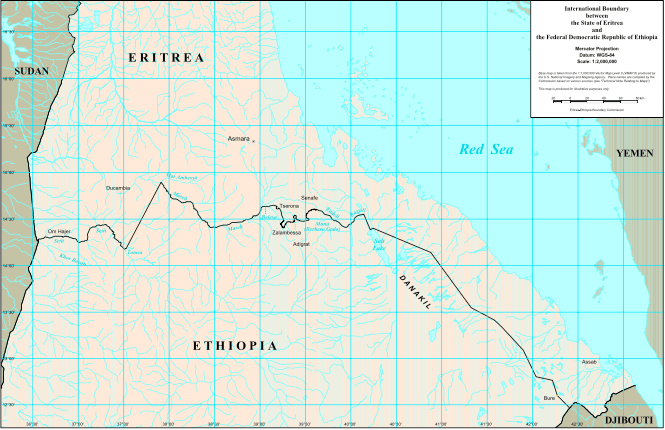
The Geology of Eritrea
 The geological set up of Eritrea is made up of Precambrian basement rocks that are overlain un-conformably by predominantly Mesozoic sedimentary rocks and Tertiary to Quaternary volcanic and sedimentary rocks.
Precambrian Basement Rocks
Basement rocks in Eritrea cover more than 60% of the surface of the country. The basement rocks of Eritrea are part of the Arabian Nubian Shield (ANS) which are exposed in north east Africa (Egypt, Sudan, Eritrea, and Ethiopia) and in Saudi Arabia, northern and northwestern parts of Yemen and part of the western Middle East.
The shield is believed to represent a mega suture between East and West Gondwana. Archean and Paleoproterozoic continental crust rocks make the older components of the shield and occupy a very small part of the basement rocks and the major part of the shield consists of Neoproterozoic (c. 870- 670 Ma) continental-marginal and juvenile Intra-oceanic magmatic-arc rocks.
In Eritrea, the basement rocks are not well studied despite their high mineral potential. The two geological maps so far completed cover the western part of the country (Geology of Gash River Area) and the southern part of the country (Geology of Mai Dima/Kohain Area). Compilation of geologic maps at 1:250,000 scale has recently been completed for four map sheets. Other study, based largely on satellite image interpretation aided by limited ground controls, suggest that the rocks can be subdivided into four tectonic blocks or segments, separated by tectonic boundaries.
Three of these blocks, the western, central and eastern segments, underlie northern and central Eritrea, whilst the fourth, the Danakil segment, occurs in the southeastern part of the country.
The western segment, the Barka Terrain is exposed in the north-western part of the country and underlies the Barka lowlands.
It is made up of amphibolite, amphibolitefacies pelitic schist containing kyanite and staurolite, quartzite and marble.
The central segment, referred to as the Hagar Terrain, extends from the Barka River up to the Adobha Abi valley in the east, and comprises several large elliptical bodies of various tectonic units that are dominantly composed of oceanic and accretionary wedge materials. Occasionally, layered sequences of chloritic schists are seen, inter-layered with epidotic and chloritic metaba-salts, occasional thin and discontinuous marbles, and manganiferous and ferruginous cherts.
The Hagar Terrain displays an east verging thrust contact with the adjacent segment to the east. The Hagar Terrain is known to be prospective for chromite, platinum group elements, nickel, gold and copper mineralization.
The eastern segment, the Nakfa Terrain, is bounded by the Adobha Abi valley in the west and by the Red Sea escarpment to the east.
It is made up of calc-alkaline volcanic and volcanoclastic rocks conformably overlain by a metasedimentary sequence of chlorite schists, grits and polymict conglomerates with occasional pelitic sericite schists and carbonates.
The metavolcanic rocks are intruded by variably deformed plutonic to hypabyssal calc-alkaline bodies. The sequence is cut in places by post-kinematic granites and gabbros and is also transected by several narrow shear zones sub- parallel to the regional strike. The Nakfa Terrain is considered to represent a relict island arc assemblage. Several VMS (Volcanogenic Massive Sulphide) base metal occurrences and gold showings are associated with this tectonic unit.
The southern segment, The Danakil Terrain, is composed of metamorphic rocks which may be grouped into three formations:- (1) migmatitic hornblende biotite gneisses; (2) a phyllitic formation consisting of schists, conglomeratic phyllites, crystalline limestones, and graphitic schists; and (3) post-tectonic granitoids.
Recently compiled geologic map of the whole country at 1:1,000,000 scale has divided the Precambrian basement rocks into 7 domains, 5 groups and 3 formations. It is rather a more detailed presentation of the rock units of the country.
Mesozoic Sediments
The lower Mesozoic sediments are represented by the Merbet (Adigrat) Sandstone which outcrops in the southern part of the country and in the Danakil area, and is commonly intercalated with siltstones and haematitic layers. It lies unconformably over thin layers of con-glomeratic sandstones which, in places, appear to have the characteristics of a glacial deposit.
Overlying the sandstone is the Jurassic Adailo (Antalo) Limestone. This unit is exposed over a large area in the Danakil and is made up of limestones that are compact, partly shelly, fossiliferous and layered.
Alternations of quartzitic layers are present in the lower part, whilst towards the upper part the sequence becomes mainly gypsiferous to dolomitic. The Upper Sandstone forms pockets of sandstones that have been preserved from erosion. Commonly this sandstone is medium to coarse grained, light coloured, and dominantly quartzitic but partly conglomeratic.
Tertiary Volcanic and Sediments
The Tertiary volcanic can be divided into three units: (1) the plateau-forming Tertiary basalts that are predominantly olivine basalts with intercalations of intermediate lavas and tuffs; (2) the lower Afar stratified basalts composed of basaltic lava flows and tuffs that are usually found intercalated with sediments of and Danakil formation; and (3) the Afar Basalts composed of recent lava flows and volcanic cones, with minor acid to intermediate volcanic, mainly trachytes, rhyolites and ignimbrites. The Tertiary basalts are currently actively exploited for aggregates.
The Tertiary Sediments
The Tertiary sediments lie along the Rift escarpment and in central Afar. Three sedimentary formations have been identified: the Danakil, Dogali and Desset Formations.
The Danakil and Dogali Formations are of late Tertiary age and are composed mainly of limestone intercalated with conglomeratic sandstones and siltstones. They are overlain by calcareous sands with coral reefs, partly consisting of pebbles of volcanic origin, and gravels with sand, silt and clay horizons. The Desset Formation comprises sandstones, clays and fine beds of anhydrite and halite unconformably overlying the Dogali formation in the northern part of the coast, while the Red Series containing coarse clastic fresh water sediments occupies the southern part of the coast.
Quaternary Sediments
A thick evaporitic formation of bedded halite, gypsum, anhydrite, potassium and magnesium salts, with shell material fills the basin in the Danakil Depression. Deposits of sheet flood terraces, silt, sand and gravel are present in some locations occasionally covered by windblown sands. Basaltic flows and related spatter cones represent Quaternary volcanic activity in the Danakil region.
Eritrea Mining Journal, October 2012